

The live map for your Maximo Work.
Naviam GIS MapEngine es una solución cartográfica potente y de nivel empresarial centrada en ArcGIS para Maximo, diseñada para ofrecer visualizaciones espaciales rápidas, interactivas y escalables. Creado para integrar ArcGIS a la perfección con Maximo, MapEngine mejora el rendimiento, la usabilidad y la accesibilidad, lo que permite a los equipos tomar mejores decisiones basadas en los datos.
MapEngine
¿Por qué elegir Naviam GIS MapEngine?

Diseñado para flujos de trabajo del mundo real
Diseñado tanto para usuarios de campo como de oficina, facilita la administración de las órdenes de trabajo, las solicitudes de servicio y los activos en un mapa sin mayor complejidad.

Totalmente personalizable
Personalice las vistas de los mapas, los filtros y las opciones de búsqueda para que se ajusten a las necesidades únicas de su organización, sin una configuración rígida y única para todos.

Flexible y orientado al usuario
Brinda a los usuarios el control sobre cómo interactúan con los datos espaciales, con herramientas configurables que se adaptan a los diferentes flujos de trabajo.

Potente visualización de órdenes de trabajo
Muestre y filtre de forma dinámica las órdenes de trabajo y las solicitudes de servicio en función de la prioridad, el tipo de activo o el estado, garantizando que los datos correctos estén siempre en primer plano.

Integración perfecta
Funciona con sus datos y configuraciones de SIG existentes sin necesidad de software adicional o extensiones de terceros.

Optimizado para la eficiencia
La optimización de rutas, la selección de lotes y el acceso optimizado para dispositivos móviles garantizan que los equipos puedan trabajar de forma más rápida e inteligente.

Search and filter anything
Search GIS features by layer and attribute. Filter work by priority, asset type, or status.

Web-based and mobile-friendly
Runs in any browser on any device, for planners in the office and crews in the field.
¿Quién se beneficia de Naviam GIS MapEngine?
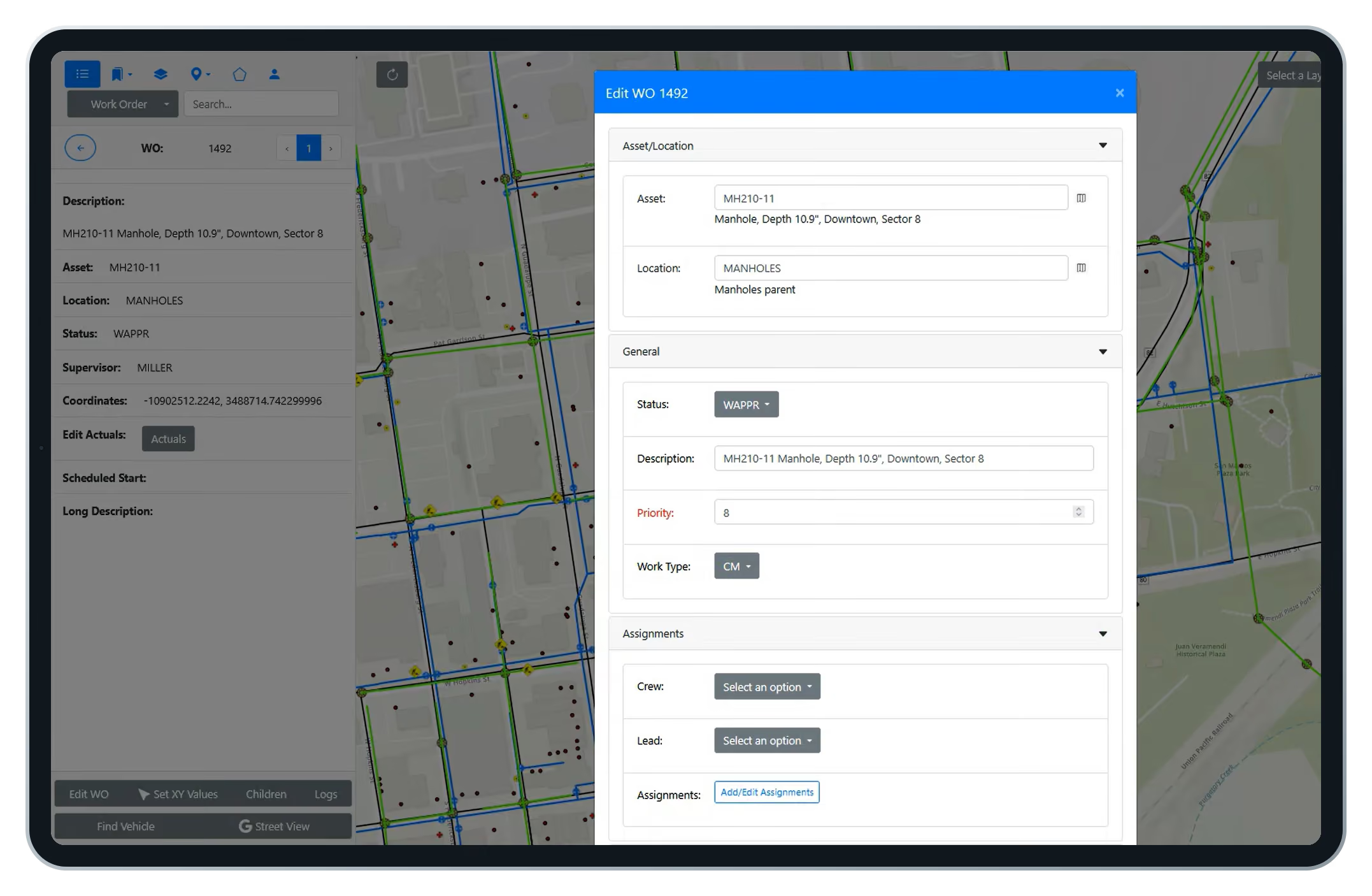
Work orders on the map open as editable forms. Change status, assign a lead, set a work group. Lasso an area and update dozens of work orders at once, the way crew chiefs plan a day.
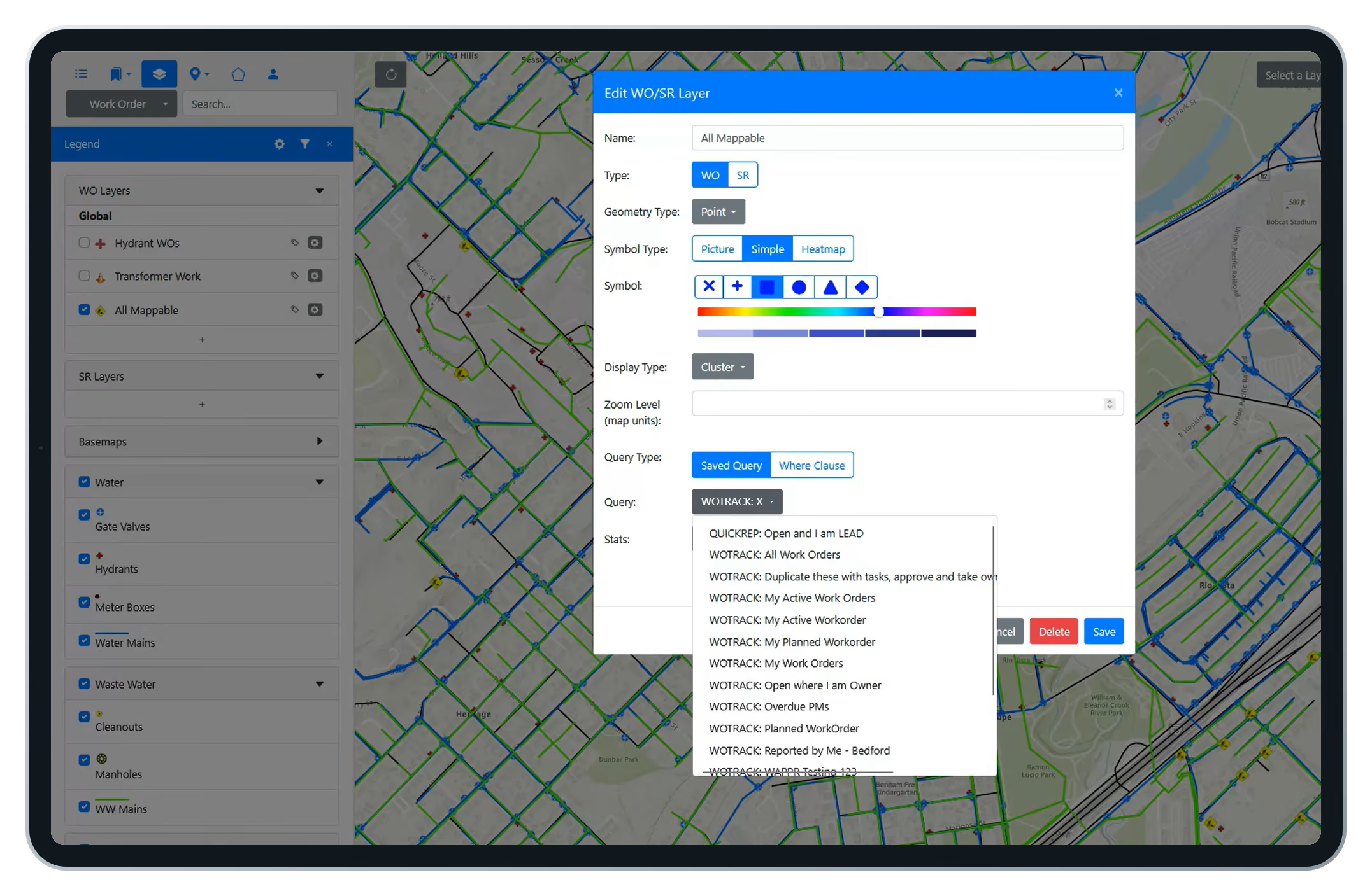
Work orders rendered from Maximo, not Esri.
Because MapEngine draws work from Maximo data, any user can define a map layer with a saved query, style its symbols, and share it with a crew or security group. No waiting on a GIS administrator.
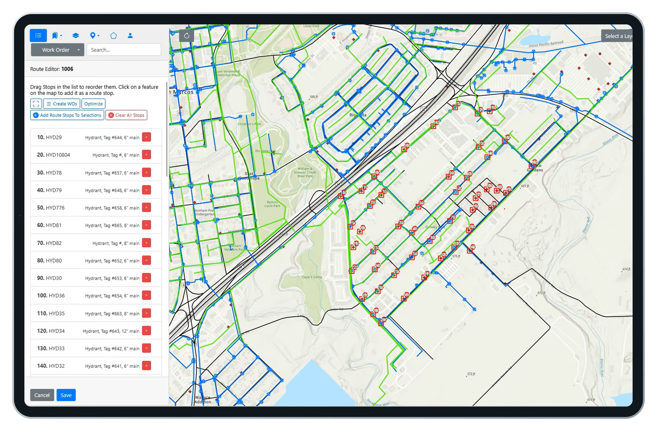
See Maximo routes in sequence. Then improve them.
MapEngine plots a route's assets in order, so the sequence is finally visible. Pick a new start point and MapEngine proposes an optimized order you can save back to the route.
MapEngine or Maximo Spatial?
What the map can do depends on what powers it.
Who benefits from MapEngine?

Electric utilities
Transformer and pole work, visualized by feeder and by crew.

Water and wastewater
Hydrants, mains, and manholes, with routes sequenced the way water flows.

Cities and municipalities
One Maximo, many departments, each with its own map profile.

Transportation and campuses
Airports, transit agencies, campuses, and gas. Any Esri-invested organization running IBM Maximo.
Field workers and crews
Locate assets, update work orders, and follow optimized routes.
Supervisors and dispatchers
Assign work by location and monitor progress.
GIS and asset managers
Keep spatial data accurate and balance workloads.
Maximo admins and IT
Manage integrations with less manual intervention.
Executives
Use spatial insight for planning and resource allocation.
Frequently Asked Questions
What is Naviam GIS MapEngine?
MapEngine is a GIS mapping application that connects Esri ArcGIS with IBM Maximo so teams can see, edit, and act on assets, work orders, and routes from a live map.
How is MapEngine different from Maximo Spatial?
MapEngine installs and updates without Maximo downtime, offers WYSIWYG configuration, per-team map profiles, self-service work order layers, editable work orders on the map, and route optimization.
How long does MapEngine take to install?
The application installs in an afternoon or less. If your GIS already carries Maximo IDs, you can be up and running in a day. Data readiness sets the timeline, not the software.
Can MapEngine be customized for different teams and workflows?
Yes. MapEngine supports configurable map views, filters, search options, layer visibility, editing permissions, and other controls so organizations can tailor the experience for field, office, operations, and GIS users.
Does installing MapEngine require Maximo downtime?
No. A one-time database configuration adds a few fields. Maximo never goes down, and updates and hotfixes can ship at any time.
Does MapEngine work with existing ArcGIS and Maximo configurations?
Yes. MapEngine uses your existing ArcGIS data and Maximo configuration. It needs no third-party extensions and no major changes to either system.
Is MapEngine mobile-friendly?
Yes. MapEngine is web-based and runs on any device, for office planning and field execution alike.
Where do the work orders on the map come from?
From Maximo, not Esri. XY coordinates live on the work order and service request tables, so any user can define map layers with a Maximo saved query.
Do I need PowerSync to use MapEngine?
Yes. MapEngine is web-based and runs on any device, for office planning and field execution alike.PowerSync populates the XY coordinates and GIS reference fields MapEngine relies on. They are designed to work together and most customers deploy both. See PowerSync.
See your Maximo data in a whole new way.
See your Maximo data in a whole new way.
Discover how Naviam GIS MapEngine transforms spatial insights into action—schedule a demo today.
.avif)
