

The live map for your Maximo Work.
Naviam GIS MapEngine is een krachtige, op ArcGIS gerichte kaartoplossing op bedrijfsniveau voor Maximo, ontworpen om snelle, interactieve en schaalbare ruimtelijke visualisaties te leveren. MapEngine is gebouwd om ArcGIS naadloos te integreren met Maximo en verbetert de prestaties, bruikbaarheid en toegankelijkheid, waardoor teams betere datagestuurde beslissingen kunnen nemen.
MapEngine
Waarom kiezen voor Naviam GIS MapEngine?

Gemaakt voor workflows uit de echte wereld
Ontworpen voor zowel gebruikers in het veld als op kantoor, waardoor het eenvoudig is om werkorders, serviceaanvragen en bedrijfsmiddelen op een kaart te beheren zonder extra complexiteit.

Volledig aanpasbaar
Pas kaartweergaven, filters en zoekopties aan de unieke behoeften van je organisatie aan, zonder een rigide, voor iedereen geschikte configuratie.

Flexibel en gebruikersgestuurd
Geeft gebruikers controle over hoe ze omgaan met ruimtelijke gegevens, met configureerbare tools die zich aanpassen aan verschillende workflows.

Krachtige visualisatie van werkorders
Werkorders en serviceaanvragen dynamisch weergeven en filteren op basis van prioriteit, activatype of status, zodat de juiste gegevens altijd centraal staan.

Naadloze integratie
Werkt met uw bestaande GIS-gegevens en -configuraties zonder dat er extra software of uitbreidingen van derden nodig zijn.

Geoptimaliseerd voor efficiëntie
Route-optimalisatie, batchselectie en mobielvriendelijke toegang zorgen ervoor dat teams sneller en slimmer kunnen werken.

Search and filter anything
Search GIS features by layer and attribute. Filter work by priority, asset type, or status

Web-based and mobile-friendly
Runs in any browser on any device, for planners in the office and crews in the field
Wie heeft er baat bij Naviam GIS MapEngine?
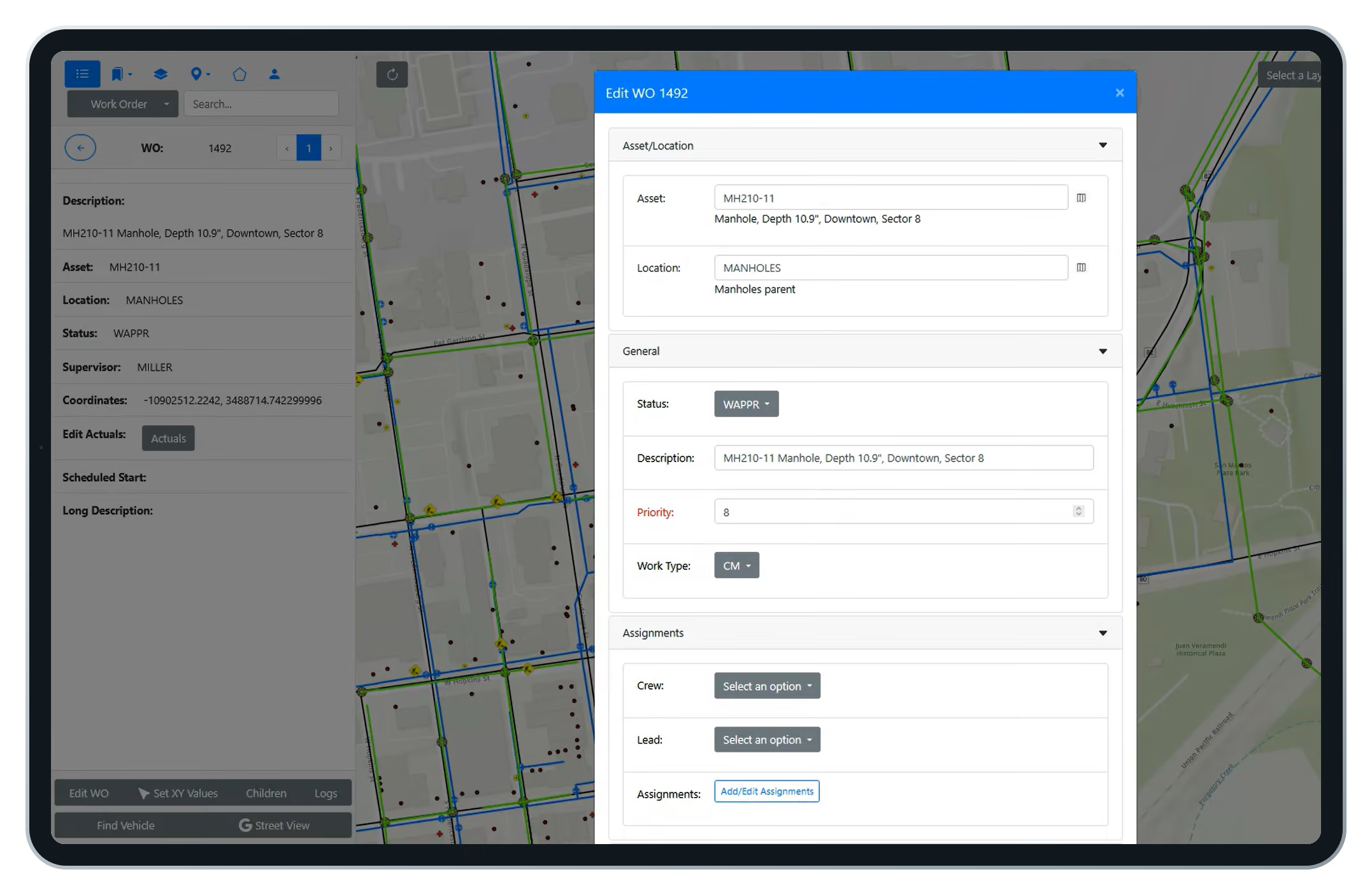
Work orders on the map open as editable forms. Change status, assign a lead, set a work group. Lasso an area and update dozens of work orders at once, the way crew chiefs plan a day.
Work orders rendered from Maximo, not Esri.
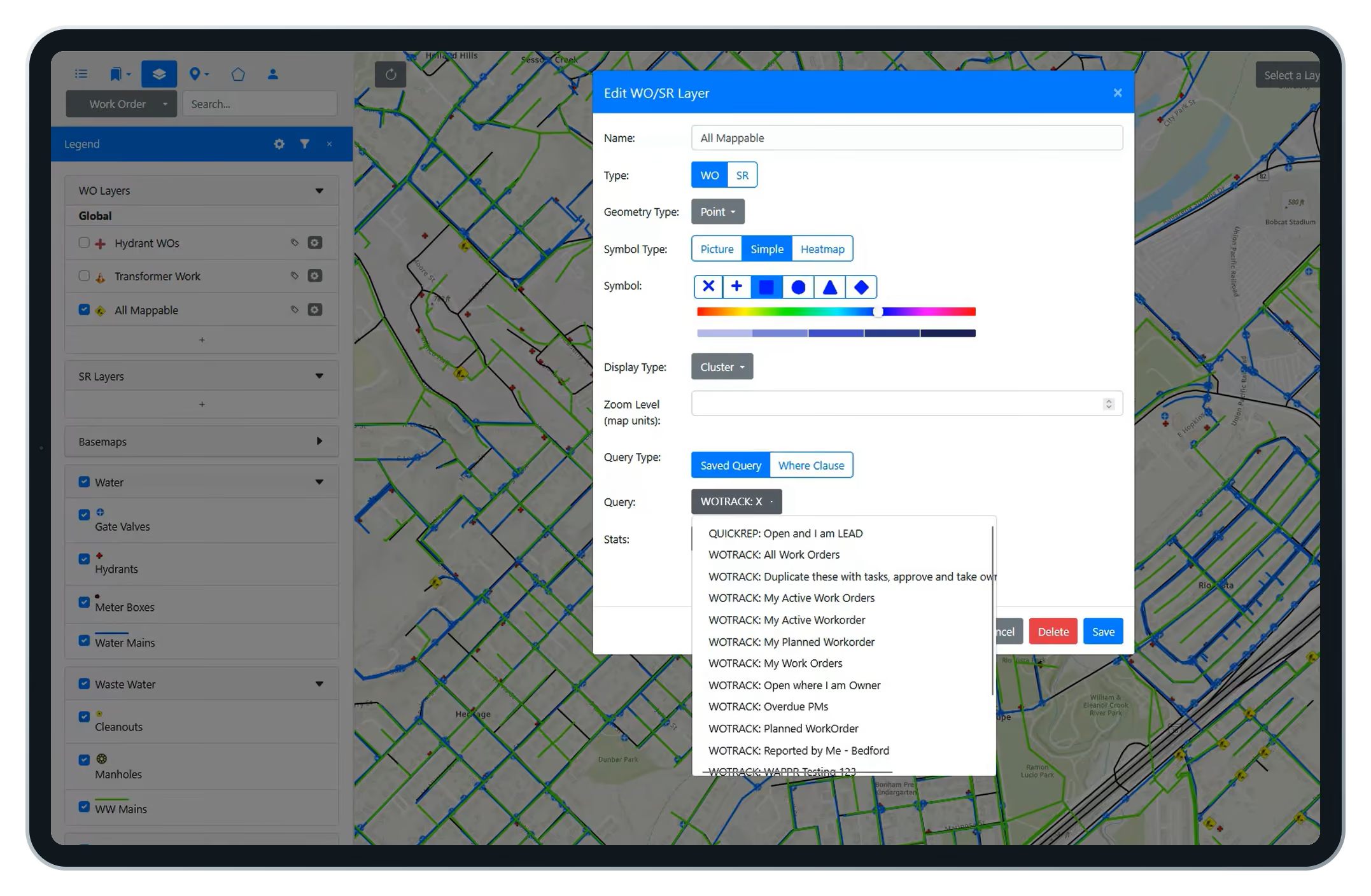
Because MapEngine draws work from Maximo data, any user can define a map layer with a saved query, style its symbols, and share it with a crew or security group. No waiting on a GIS administrator.
See Maximo routes in sequence. Then improve them.
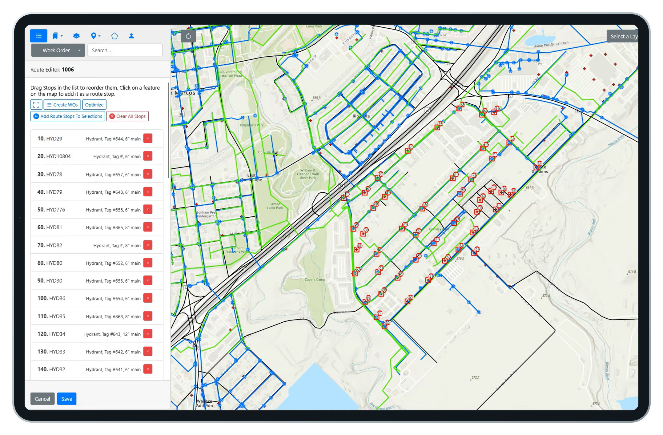
MapEngine plots a route's assets in order, so the sequence is finally visible. Pick a new start point and MapEngine proposes an optimized order you can save back to the route.
MapEngine or Maximo Spatial?
What the map can do depends on what powers it.
Who benefits from MapEngine?

Electric utilities
Transformer and pole work, visualized by feeder and by crew

Water and wastewater
Hydrants, mains, and manholes, with routes sequenced the way water flows

Cities and municipalities
One Maximo, many departments, each with its own map profile

Transportation and campuses
Airports, transit agencies, campuses, and gas. Any Esri-invested organization running IBM Maximo
Field workers and crews
Locate assets, update work orders, and follow optimized routes
Supervisors and dispatchers
Assign work by location and monitor progress
GIS and asset managers
Keep spatial data accurate and balance workloads
Maximo admins and IT
Manage integrations with less manual intervention
Executives
Use spatial insight for planning and resource allocation
Frequently Asked Questions
What is Naviam GIS MapEngine?
MapEngine is a GIS mapping application that connects Esri ArcGIS with IBM Maximo so teams can see, edit, and act on assets, work orders, and routes from a live map.
How is MapEngine different from Maximo Spatial?
MapEngine installs and updates without Maximo downtime, offers WYSIWYG configuration, per-team map profiles, self-service work order layers, editable work orders on the map, and route optimization.
How long does MapEngine take to install?
The application installs in an afternoon or less. If your GIS already carries Maximo IDs, you can be up and running in a day. Data readiness sets the timeline, not the software.
Can MapEngine be customized for different teams and workflows?
Yes. MapEngine supports configurable map views, filters, search options, layer visibility, editing permissions, and other controls so organizations can tailor the experience for field, office, operations, and GIS users.
Does installing MapEngine require Maximo downtime?
No. A one-time database configuration adds a few fields. Maximo never goes down, and updates and hotfixes can ship at any time.
Does MapEngine work with existing ArcGIS and Maximo configurations?
Yes. MapEngine uses your existing ArcGIS data and Maximo configuration. It needs no third-party extensions and no major changes to either system.
Is MapEngine mobile-friendly?
Yes. MapEngine is web-based and runs on any device, for office planning and field execution alike.
Where do the work orders on the map come from?
From Maximo, not Esri. XY coordinates live on the work order and service request tables, so any user can define map layers with a Maximo saved query.
Do I need PowerSync to use MapEngine?
Yes. MapEngine is web-based and runs on any device, for office planning and field execution alike.PowerSync populates the XY coordinates and GIS reference fields MapEngine relies on. They are designed to work together and most customers deploy both. See PowerSync.
See your Maximo data in a whole new way.
See your Maximo data in a whole new way.
Discover how Naviam GIS MapEngine transforms spatial insights into action—schedule a demo today.

