Naviam-producten
Naviam biedt een krachtige reeks producten die zijn ontworpen om uw Maximo-ervaring te verbeteren en te vereenvoudigen. Van mobiele apps en geospatiale tools tot geavanceerde plannings-, rapportage- en leveranciersbeheeroplossingen: onze producten verbeteren de productiviteit, stroomlijnen de activiteiten en geven u meer controle over uw vermogensbeheeromgeving. Alles werkt slimmer met Naviam.

Slimmere mobiele tools voor Maximo
Opqo van Naviam
Opqo levert een schone, efficiënte mobiele interface voor IBM Maximo, ontworpen om eenvoudig te kopen, te configureren en te gebruiken. Omdat en er geen voorafgaand project nodig is, kunt u met Opqo naadloos en flexibel aan de slag. Het is volledig procesgestuurd en ongelooflijk eenvoudig, maar krachtig genoeg om echte veldoperaties te ondersteunen, zelfs offline.

EzMaxMobile van Naviam
EZMaxMobile is een krachtige mobiele oplossing voor IBM Maximo, die realtime en offline toegang, geavanceerde functies en wereldwijde schaalbaarheid biedt om de productiviteit in het veld te verhogen en de activiteiten van Maximo te stroomlijnen.

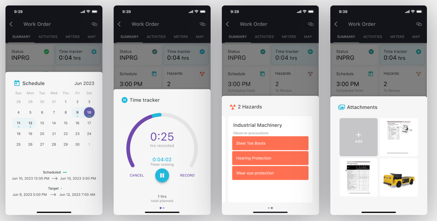
Fingertip van Naviam
Fingertip van Naviam is een configureerbare, offline compatibele mobiele oplossing voor Maximo die essentiële activa-, werk- en voorraadbeheer naar veldteams brengt, zonder extra infrastructuur, aangepaste ontwikkeling of vertragingen bij de implementatie.
Vereenvoudigd operationeel beheer

Naviam Planner
Naviam Planner vereenvoudigt de onderhoudsplanning van Maximo met een intuïtieve interface met slepen en neerzetten. Het optimaliseert de resourceplanning, verbetert de zichtbaarheid en vermindert de uitvaltijd, waardoor teams werkorders efficiënt en in realtime kunnen beheren.

Naviam-aanvraag
Naviam Request vereenvoudigt serviceaanvragen met een gebruiksvriendelijk portaal dat medewerkers, serviceteams en Maximo in realtime met elkaar verbindt. Stroomlijn de indiening, verbeter de reactietijden en verbeter de communicatie — alles in één oplossing.
Inzichten zonder code en gegevensbeheer

Geïntegreerde GIS voor Maximo

PowerSync
Geautomatiseerde gegevenssynchronisatie die zorgt voor naadloze updates tussen belangrijke bedrijfssystemen, waardoor handmatige processen worden geëlimineerd en de nauwkeurigheid van de gegevens behouden blijft.

Workflows
Geavanceerde GIS-gegevensintegratie, waarbij ruimtelijke informatie en informatie over bedrijfsmiddelen op verschillende platforms gesynchroniseerd blijft, wat zorgt voor betrouwbaardere activatracering én beter infrastructuurbeheer.

MapEngine
Een krachtige GIS-oplossing die snelle, interactieve en responsieve ruimtelijke visualisaties mogelijk maakt, geoptimaliseerd voor desktop en mobiel.

Inspectie vanuit de lucht
(Transmission Line Aerial Patrol Inspection App) — Een gespecialiseerde iPad-tool die is ontworpen voor patrouille-inspecties vanuit de lucht, met geautomatiseerde structuurdetectie, GIS-integratie en offline-mogelijkheden.
Ontdek de volledige kracht van Naviam-producten
Ontdek de volledige kracht van Naviam-producten
Van het veld tot op kantoor, onze tools ontsluiten het volledige potentieel van uw Maximo-omgeving. Klaar om slimmer te werken? Laten we aan de slag gaan.
.avif)